
Oakmead Herbarium: Some Jasper Ridge Place Names
Oakmead Herbarium home | Arrivals, Weeds | Floristic References | Place Names | Maps and Vegetation Surveys
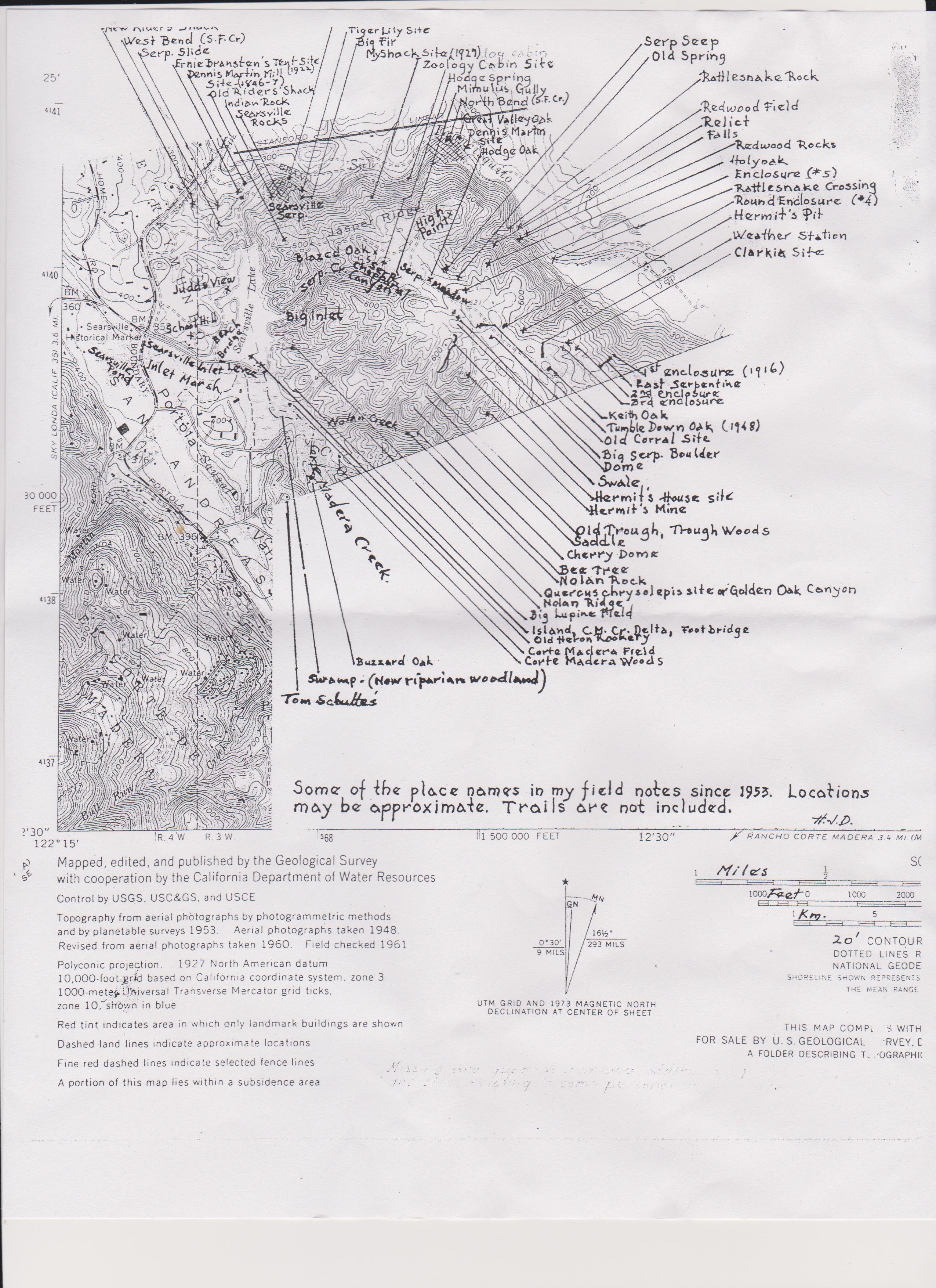
➽Dengler, H. Some of the place names in my field notes since 1953 | Google Earth version (Affiliates)
➽ For photo archive use the search in Flickr.com: jrbp [place name], e.g., "jrbp causeway" or follow the links  Photo
Photo
➽ Sector Map Book of Jasper Ridge Biological Preserve, March 2005
- Area C Serpentine Prairie, N end of Ridge, Sector 23, 24, 33 (map)
- Area H Serpentine, W of Escobar Gate, Sector 35 (map)
- Baby blue-eyes site (uphill from Trail 11) (37.401102°,-122.230657°) Photo
- Bear Creek at Preserve Boundary, Sector 12 B3 (37.411111°,-122.241204°)
- Big Bay Tree, Sector 43 B2 (37.398555°,-122.218833°)
- Big Inlet, Searsville Lake, Sector 31 A1–2, B1–2, C1–2 Photo
- Big Oak Pocket Meadow (37.408557,-122.219557) on Trail 2 south of Trail 3 intersection
- Bird Foots Fern site north of Trail 9, Sector 31 C3 (37.401840°,-122.234932°) Photo
- Bird Foots Fern site Nolan Cr. Photo
- Bird Trail between Rd F and Trail 7
- Boat Launch (Searsville Lab Landing), Sector 30 D2 (37.403123°,-122.238486°)
- Boething Crossing, Sector 25 E3, easy access to San Francisquito Creek from Trail 2 Extension near Preserve boundary
- Boat Ramps (Old) Sector 30 A4–C4
- Brewer's Onion site Photo
- Caretakers Residence/Corporation Yard, Sector 29 D3 (37.401883°,-122.244523°)
- Carex Swale, Sector 34 B4 (37.400743°,-122.218443°). From Rd F near its intersection with Tr 16 go WSW into a small drainage that flows to the Preserve’s southern boundary
- Carol Zabel Commemorative Site Photo
- Causeway, raised path south of Searsville Lake terminated by Causeway Bridge and Leonard’s Bridge, Sectors 30–31 Photo
- Causeway Bridge, Sector 30 C4 (37.400913°,-122.239916°)
- Cave Trail, Sector 13 B3 (37.410949°,-122.236817°) 103 m
- Chia Site Trail b, Sector 23 B4
- C.M.F. (Dengler-assigned location) = Corte Maderia Field, SW corner of Preserve, northeast of Mapache Gate along Trail 12
- Corte Madera Creek
- Corte Madera Cr Flood Plain (Searsville Lake–Corte Madera Cr Delta), Sector 30–31
- Corte Maderia Field, SW corner of Preserve, northeast of Mapache Gate along Trail 12
- Dengler Transect from San Francisquito Creek to ridgetop follows an overgrown road from Trail 2 at 268 ft. (37.4079208, -122.21917958) up to the ridge-top serpentine.
- Dennis Martin Site Marker, Sector 15 C1
- Douglas Iris Site, Sector 12 D4 (37.409742°,-122.238619°) Photo
- Eleocharis Meadow (a former quarry and currently a de facto wetland) Sector 31 B4 near the intersection of Road E and Trail 13 SE of Searsville Lake (37.400807°,-122.236106°).
- Escobar Gate, Sector 43 E5
- Garrya Trail = Trail b
- Goya Gate, Sector 43 E2
- Hermit Cabin Site, Sector 42 D1 (37.399750°,-122.222150°)
- Hermit Cabin Meadow, Sector 33 D4-D5 (37.400407°,-122.221819°)
- Hermit Mine, Sector 42 E2 (37.398070°, -122.220672°)
- Hillside Lab, Sector 22 B2 (37.407890°,-122.235637°)
- Hodge Spring, serpentine, Big Inlet drainage, (37.406505°, -122.228558°; 525')
- Hollow Oak, Sector 43 C1 (37.398884°,-122.217420°)
- Leonard's Bridge, Sector 31 A5
- Leopard Lily Site, Sector 13 C4-D4 (37.410032°,-122.233867°) Photo
- Lost Serpentine (steep NE facing hillside crossed by trails 5 and 6 on uphill side)
- Low Flow Crossing, San Francisquito Cr, Sector 12 E3 (37.410691°,-122.237824°)
- Mapache Hill Trail, Trail e, Trail Map 12/88
- Middle Lake (Inlet Marsh), Sectors 29–30
- Mimulus Gully (West Serpentine Chaparral), Sector 23 D5 (37.404823°, -122.228135°; 527 ft) Photo
- Nolan Creek (Westridge Fork of Corte Madera Cr.), approach by Trail d, Hermit's Mine Trail, Trail Map 12/88
- Nolan Ridge (Divide on west side of Westridge Creek); map
- Oak Woodland Loop, Trail j, Trail Map 12/88
- Old Bathing Beach, Sector 30 D3–D4
- Old Boat Ramp(s), Sector 30 A4–C4
- Phalaris californica Seep, Sector 24 B3 (37.406070°,-122.224450°) Photo
- Quarry off Trail 12, Sector 31 B5 (37.400124°,-122.235380°) Plant list
- Rattlesnake Rocks (formerly Searsville Rocks), Sector 13 B4 (37.410614°,-122.236491°)
- Red Hot Poker Meadow, Sector 21 A1 (37.408578°,-122.242075°)
- Riders' Shack, now called the Hillside Lab, Sector 22 B2 (37.407890°,-122.235637°)
- San Francisquito Creek
- San Francisquito Creek adjacent to Dennis Martin site Photo
- Searsville Dam (high water)
- Searsville Lake–Corte Madera Cr Delta, Sector 30–31
- Searsville Lab Landing, Sector 30 D2 (37.403123°,-122.238486°) Photo
- Searsville Pond (Upper Lake), west of Portola Rd.
- Searsville Rocks (aka Rattlesnake Rocks), Sector 13 B4 (37.410614°,-122.236491°)
- Semaphore Grass Meadow, a vernal wet depression, Sector 20 E5 (37.404870°,-122.243453°) Photo ; rapid vegetation assessment
- Serpentine Creek Canyon (Big Inlet drainage); main approach by Tr b or from Rd. F
- SF Cr = San Francisquito Creek, by convention begins below Searsville Dam
- SLAC Corridor = area NE of SF Cr in Sectors 6, 15–16
- Sun Field Station, Sector 21 C4
- Sun Field Station Visitor Parking, Sector 21 B5-C5
- Trail 1 Serpentine, Sector 13 C4-D4 (includes Tiger Lily Site)
- Trail 2 extension, NE side of Jasper Ridge in Sectors 15, 25, 35 (includes former portion of Trail 1 (between Tr 5 and Tr 3)
- Trail 2 extension Cistern Site
- Trail 2 white and green post meadow (37.40848°, -122.219434°)
- Trail 10 Meadow, Sector 33, B3-B4 (37.401671°,-122.224203°)
- Trevor’s Knoll, above Trail 10 (37.400390°, -122.228658°)
- Upper Lake (Searsville), west of Portola Rd.
- West Serpentine Chaparral, Sector 23 C3–5 & D3–5 Photo
- Wislizeni Trail = Tr. c Photo. Several small trees are now considered Coast live oak/Shreve oak hybrids
- Zoology Cabin foundation, Trail 2, Sector 14 E3 (37.411410°,-122.226225°) Photo
Oakmead Herbarium home | Arrivals, Weeds | Floristic References | Place Names | Maps and Vegetation Surveys
